
PDFWAC 173-503-040
Establishment of instream flows.
(1) Stream management units and associated control stations are established as follows:
Stream Management Unit Information
Stream Management Unit Name Control Station No. | Control Station by River Mile and Section, Township and Range; Latitude and Longitude | Stream Management Reach | |
Skagit Mainstem: | |||
Skagit River near Mt. Vernon, WA USGS Sta. #12-2005-00 | River Mile (RM) 15.7 | From mouth of Skagit River including tidal fluctuation to headwaters.* | |
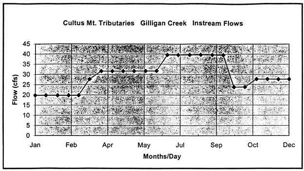
Cultus Mountain Tributaries: | |||
Mundt Creek | Stream gage will be installed at RM 3.4 (Sec/Twn/Rng; Lat/Long) | From mouth to headwaters. | |
Turner Creek | Stream gage will be installed at RM 4.2 (Sec/Twn/Rng; Lat/Long) | From mouth to headwaters. | |
Gilligan Creek | Stream gage will be installed at RM 3.2 (Sec/Twn/Rng; Lat/Long) | From mouth to headwaters. | |
Salmon Creek | Staff gage periodically recorded will be installed at RM 4.3 (Sec/Twn/Rng; Lat/Long) | From mouth to headwaters. | |
*Other additional control stations and instream flows may be established in WRIAs 3 & 4 to improve water management. | |||
(2) Instream flows are established for the stream management units in WAC 173-503-040(1) as follows (See Figures 1 through 3):
Instream Flows as measured at USGS Sta. #12-2005-00 (Instantaneous cubic feet per second)
Month | Day | USGS Sta. #12-2005-00 Skagit River |
Jan. | 1–31 | 10,000 |
Feb. | 1–29 | 10,000 |
Mar. | 1–31 | 10,000 |
Apr. | 1–30 | 12,000 |
May | 1–31 | 12,000 |
Jun. | 1–30 | 12,000 |
Jul. | 1–31 | 10,000 |
Aug. | 1–31 | 10,000 |
Sep. | 1–30 | 10,000 |
Oct. | 1–31 | 13,000 |
Nov. | 1–15 | 13,000 |
16–30 | 11,000 | |
Dec. | 1–15 | 11,000 |
16–31 | 10,000 |
Instream Flows for Cultus Mountain Tributaries, WRIA 3 (Instantaneous cubic feet per second)
Month | Day | RM 3.4 Mundt Creek | RM 4.2 Turner Creek | RM 3.2 Gilligan Creek | RM 4.3 Salmon Creek |
Jan. | 1-31 | 6.4 | 7.9 | 19.8 | 4.0 |
Feb. | 1-29 | 6.4 | 5.4 | 19.8 | 4.0 |
Mar. | 1-15 | 6.4 | 5.4 | 19.8 | 4.0 |
16-31 | 9.4 | 5.4 | 27.7 | 4.0 | |
Apr. | 1-30 | 9.4 | 7.9 | 31.7 | 4.0 |
May | 1-31 | 9.4 | 7.9 | 31.7 | 1.4 |
Jun. | 1-30 | 9.4 | 4.9 | 31.7 | 1.4 |
Jul. | 1-31 | 7.6 | 4.9 | 39.6 | 1.4 |
Aug. | 1-31 | 7.6 | 4.9 | 39.6 | 1.4 |
Sep. | 1-30 | 7.6 | 4.9 | 39.6 | 4.0 |
Oct. | 1-31 | 7.6 | 7.9 | 23.8 | 4.0 |
Nov. | 1-30 | 9.4 | 7.9 | 27.7 | 4.0 |
Dec. | 1-31 | 9.4 | 7.9 | 27.7 | 4.0 |
(3) Instream flow hydrograph.
Figure 1
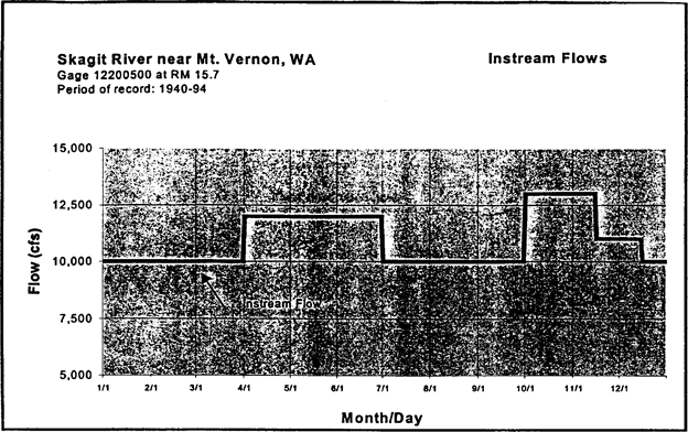 |
Figure 2
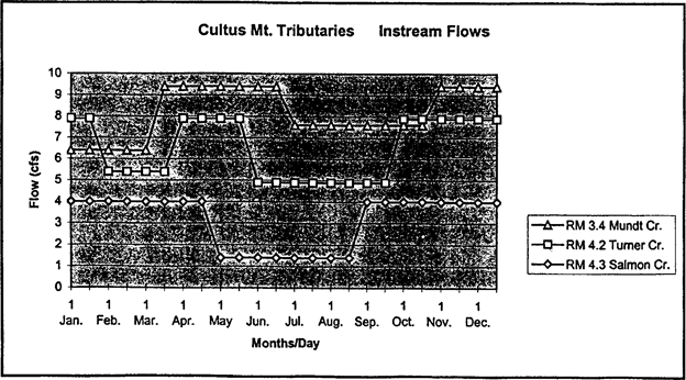 |
Figure 3
 |
(4) The instream flow hydrographs, as represented in Figures 1 through 3 in WAC 173-503-040(3) shall be used for identification of instream flows.
(5) Future consumptive water right permits issued hereafter for diversion of surface water in the Lower and Upper Skagit (WRIA 3 and 4) and perennial tributaries, and withdrawal of groundwater in hydraulic continuity with surface water in the Skagit River and perennial tributaries, shall be expressly subject to instream flows established in WAC 173-503-040 (1) through (3) as measured at the appropriate gage, and also subject to WAC 173-503-060.
(6) Future consumptive water rights issued to applications pending at the effective date of the regulation are superior in priority date but shall be conditioned on the instream flows established in WAC 173-503-040 (1) through (3). (RCW 90.03.247)